
Saint-Radegonde, Alignments and Talmont-sur-Gironde - S13-E18
- Mar 20
- 13 min read
In Episode 18 of Season 13 of The Curse of Oak Island, I presented research on a group of medieval churches, a saintly woman, and—more controversially—alignments to the island. I know what some people say about alignments. I’ve often heard the phrase “you can make any alignment with two points,” which is, of course, a perfectly valid argument; it wouldn’t be rational to draw a random line between two points and call it an alignment.
Generally, I consider myself a relatively rational person. Admittedly, after spending years researching mysterious places — including Oak Island — I may have developed a certain fondness for the weird and wonderful. But on the broad spectrum of mystery researchers, I still like to think I fall somewhere on the more reasonable end.
“What?” I can almost hear some of you saying — especially after seeing my presentation on The Curse of Oak Island, the one about medieval churches aligned towards Oak Island, a line of research that began with a single word on a map I don’t even consider reliable. That hardly sounds very reasonable.
So perhaps a little context is needed.
Firstly, what is an alignment? An alignment refers to a straight-line relationship between sites that goes beyond a simple two-point connection. It may involve three or more locations falling along the same line, or two points defined by an existing axis — such as the orientation of a building or feature — extending outward to intersect other sites. The key idea is a consistent direction, rather than simply a line drawn between two places.
My work on Oak Island has never primarily been about alignments. At heart, I’m a document and archive researcher. Much of my time is spent digging through archives in search of historical connections, often in collaboration with others working on the subject — including Daniel Spino on this website and researchers whose work may be familiar to viewers of the show, whether on screen or behind the scenes.
And that means thousands of pages of documents: ship logs, correspondence, legal records, genealogies, forgotten references buried in obscure books — anything that might shed light on the island, or on the people who may have been connected to whatever happened there. I’m also fortunate to speak the two languages of the main colonial powers in Nova Scotia’s early history, which is a considerable advantage when working with these sources.
Alignments, for me, began almost as a side curiosity. And even after more than ten years of exploring the possibility that some of them might be intentional, I remain fully aware that coincidence is still a possibility. Anyone claiming absolute certainty in this field clearly has insights that I do not.
Being on the show is a unique and memorable experience. Your short appearance on The Curse of Oak Island — which usually represents only a small fragment of a much longer presentation — is ultimately edited for entertainment. However carefully you try to explain your ideas with the necessary caution, precision and nuance, those subtleties do not always make the final cut. Researchers who have gone through the process tend to understand this. Quite simply, there is not enough time to fully develop a researcher’s ideas within the show's format.
This is why I would like to add nuance and context to the conclusions that can be drawn from my presentation.
The alignment story began with the first airing of the "Don Ruh Map" - generally known today as the “Zena Map.” When the map was first shown on The Curse of Oak Island, I was genuinely surprised to see it presented as a medieval French document - I personally do not think it is.
Over the years I have made my views on the map quite public. Together with Daniel, my friend and co-author of this blog, we produced a five-part investigation examining the document in detail called the Bill Jackson Investigation. I would strongly encourage readers to look at the full series — yes, it's long, it represents about an hour of reading — but if one intends to fully understand the map, it is probably worth taking the time to examine the real evidence first. The first part of the investigation can be found here.
To summarise our findings, and without any intention of being disrespectful to Zena Halpern or to those who consider this map to be authentic, our analysis of the French annotations indicates quite clearly that it could not have been written before the nineteenth century. The other documents associated with it—including the so-called Cremona material and several related letters—present similar issues: inconsistent language, clear etymological anachronisms, and, in some cases, signatures that appear to have been fabricated. Furthermore, the numerous grammatical errors strongly suggest that the author was not a native French speaker.
Taken together, these elements indicate that the map and the associated documents are most likely modern creations rather than genuine medieval sources. We also conclude that they are unlikely to be copies of older material, as their provenance is, to put it cautiously, highly questionable.
That said, the "Don Ruh Map" does contain references that appear to correspond with certain features and stories associated with Oak Island. During another close study of the document in 2022 — by which time I had become convinced that it had most likely been created by Don Ruh himself — I began examining every name and expression written on it.
One particular phrase caught my attention: “Lionceau of Talmont” — the lion cub of Talmont.

There are actually two notable places in France named Talmont. The first is Talmont-Saint-Hilaire (the subject of detailed research by author Gretchen Cornwall, whose work is worth consulting), and the second is Talmont-sur-Gironde. Both are located on the Atlantic coast, in regions historically connected to the early French presence in Nova Scotia. While researching Talmont-sur-Gironde, I noticed two intriguing details: the church in the village has a rather unusual orientation, and there also appears to be a striking symbolic association with a lion.
And this is where the alignment story really begins.
The Church of Sainte-Radegonde in Talmont-sur-Gironde stands in a spectacular location on a rocky promontory overlooking the Gironde estuary, almost as if it rises directly out of the sea. The present building was probably constructed around 1094 by the Benedictines of Saint-Jean-d’Angély, replacing an earlier chapel. The site may also have served as a stopping point for pilgrims travelling toward Santiago de Compostela, who could cross the estuary here before continuing their journey, although the exact role of the church in the pilgrimage network remains uncertain.

In the 13th century, when the region was under the rule of Edward I of England, the church was fortified and a defensive walkway was added above the apse. Later restorations attempted to return the building to an idealised Romanesque appearance, which may have obscured some earlier architectural details.
In 1929, excavations beneath the church uncovered a crypt carved into the rock. Coins from the Carolingian period — the era of Charlemagne and his successors, roughly the 8th to 10th centuries — were discovered during the excavation. The site has long been associated with maritime burial traditions, and the cemetery surrounding the church is often connected to local stories with sailors and people from the nearby coast.
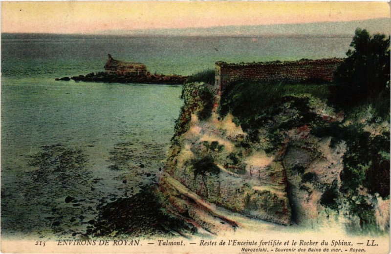
An old Romanesque coastal church? Hardly groundbreaking. However, opposite the church once stood a curious rock formation known as the Rocher du Sphinx, so called because its shape supposedly resembled a sphinx. That, in itself, is unusual. There are other rocks in France bearing that name, but none quite as remarkable. At the time, I wasn’t entirely sure what to make of its possible connection to the map. Perhaps the map’s creator had simply come across this peculiar landmark and chosen to include it in an already cryptic document.
The Sphinx of Talmont even appeared on postcards and seems to have been well known locally. In 1917, following the United States’ entry into the war, plans were made to establish a dedicated port in France for the landing of American troops and material, and Talmont-sur-Gironde was selected for this purpose. Unfortunately, the rock was completely destroyed during the First World War in connection with these works. The project was soon abandoned, but by then the sphinx had already been blown up. It is important to note that the Sphinx Rock is generally considered to have been a natural formation, its distinctive shape the result of erosion — something I later confirmed with a local guide.


But there may be another “lion” connection. The Church includes animal sculptures typical of the Saintonge region (area around the city called Saintes), among them a small lion-like figure carved into the stone decoration. Lions were common symbolic motifs in Romanesque churches of the 11th and 12th centuries, and similar carvings can be found on many churches in the region.
Could this sculpture be the “Lionceau de Talmont” mentioned on the Don Ruh map? It is possible that the reference relates simply to this visible architectural detail of the church, rather than to a person or a more complex symbolic meaning. However, there is no evidence to confirm this interpretation.
Does this mean the map itself is medieval or genuine? Not at all. It simply suggests that whoever wrote the caption “Lion cub of Talmont” may have been aware of this sculptural detail on the church, and perhaps also of the nearby Sphinx Rock.
Lions aside, the orientation of the church itself is intriguing. This is not entirely unusual — many churches in France are not perfectly aligned along the traditional east–west axis recommended for medieval construction — but it was enough to spark my curiosity. I decided to see what would happen if I extended the line of the building’s main axis. In other words, if one follows the direction of the roof ridge — the highest line of the church — and continues that line across the map, it travels westward… across the Atlantic… and arrives on Oak Island.

Now, before anyone reaches for the pitchforks, yes — I am perfectly aware that this could simply be a coincidence.
But curiosity being what it is, I then looked at the other arm of the church’s cross-shaped plan. I followed the axis of the transept, which sits at a right angle to the main body of the church. Tracing that line across France toward the east, although there was no exact correspondence, I noticed that it passed very close to a chapel dedicated to the same saint — Saint-Radegonde.
Located just outside the small village of Courant, the chapel again appeared to have an unusual orientation. Naturally, curiosity got the better of me again, so I traced the axis of that chapel as well. To my surprise, its direction — roughly a north-west azimuth of 292° — was almost identical to that of the church at Talmont-sur-Gironde. And when that line was extended westward… it too appeared to end up on Oak Island.

By now I was beginning to wonder what this might mean. Until that moment I had never even heard of Saint-Radegonde. Looking further on the map, I noticed yet another church dedicated to the same saint (Our Lady of Sainte-Radegonde), located roughly between the first two sites. In fact, the entire village was named after her. Once again, the church showed a similar north-west orientation, with an azimuth of around 292°. When I followed the axis of that church as well, the line once again arrived on the island.

Measured relative to true (geographic) north, the 292° azimuth is an approximate value rather than a fixed number. The exact azimuth for each church varies slightly with latitude, as each site occupies a different position while aligning toward the same destination. In practice, this means the decimal component shifts depending on how far north or south a site is located. For example, a Saint-Radegonde site further north of Talmont shows an azimuth around 0.3° lower, while a site further south shows a slightly higher value. It is also worth noting that the calculated azimuth can vary slightly depending on the software used. For example, measurements taken in Geoportail and Google Earth do not always produce identical values. But the direction does remain the same.
At that point I began to question whether I might simply be seeing patterns where none existed. To be sure I wasn’t deluding myself, I contacted several researcher friends and asked them to check the measurements independently. Their conclusion was the same: the alignments appeared to be real.
I explored the possibility of a common origin for these three Saint-Radegonde sites. A closer look reveals both shared Benedictine influence and a common Romanesque Saintongeais architectural context. It is therefore likely that these sites were constructed by builders working within interconnected abbeys, rather than by a single unified group..
My next step was to learn more about this saint I had never heard of before. Saint-Radegonde (c. 520–587) was a Frankish queen who later became a nun and was eventually canonised. The Franks were a group of Germanic tribes who ruled much of Western Europe after the fall of the Roman Empire and ultimately gave their name to France.
Radegonde was born a Thuringian princess, in what is now Germany. She was captured during a Frankish military campaign and later married by force to King Clotaire I of the Merovingian dynasty. Eventually she left the royal court to devote herself entirely to religious life. She founded the Abbey of Sainte-Croix in Poitiers, one of the earliest convents for women in Western Europe. Radegonde is also remembered for obtaining a relic believed to be a fragment of the True Cross — the cross on which Jesus was crucified — sent to her by the Byzantine emperor Justin II. This relic greatly increased the prestige of her monastery and contributed to the spread of her cult.
Interestingly, Radegonde is sometimes depicted holding a book bearing a cross surrounded by four dots. This is particularly intriguing given the four-dot cross that appears on the supposed H+O stone. In Christian iconography, saints holding a book generally symbolize the transmission of sacred teaching and knowledge, the book representing the Gospel and the wisdom of the Christian faith. The cross with four dots has often been interpreted as a motif representing Christ at the centre with the Gospel spreading to the four corners of the world. Given that Saint-Radegonde famously obtained a relic of the True Cross for her monastery at Poitiers, the presence of a cross on the book may symbolically combine these ideas — sacred knowledge centred on the Cross.

After her death in 587, Radegonde was widely venerated, and many churches, chapels, and even holy springs across France were dedicated to her.
To better understand whether the Oak Island alignments might simply be coincidental, I carried out a broader test. I examined 250 churches across France, chosen at random and dedicated to a wide range of patron saints, to see whether similar alignments might appear elsewhere. Of these 250 buildings, only two appeared to align with the island — approximately 0.8%. While the sample size remains limited, and not sufficient to run a serious statistic test, this preliminary result suggests that such alignments are rare when churches are considered without prior selection.
However, the picture becomes more interesting when focusing specifically on churches dedicated to Saint-Radegonde. Out of the 98 Saint-Radegonde churches and sites identified across France, three initially appeared to align with Oak Island. Following a more detailed, individual examination of each site, two additional alignments were identified. In total, five churches or chapels appear to align with Oak Island, representing approximately 5.1% of the Saint-Radegonde network.
In other words, alignments toward Oak Island appear more than 6 times more frequently among Saint-Radegonde sites than they do among churches chosen at random. While this does not in itself prove deliberate intention, it does suggest that the phenomenon is far from evenly distributed and appears significantly more often within the Saint-Radegonde network.

But does this prove intent? That is harder to say. And what about the other 93 Saint- Radegonde churches and chapels?
This is where the project began to expand significantly. Using the full dataset of 98 Saint-Radegonde sites initially identified across France, the five sites aligned with Oak Island were set aside from the internal analysis, leaving 93 French sites. Of these, nine could not be used as sources, as their orientation cannot be reliably determined—for example, ruined churches or fountains without a clear architectural axis. This left 84 usable sites from which directional lines could be drawn.
Using the axis of each church or chapel as the reference line, 49 of these 84 sites are aligned with at least one other Saint-Radegonde site, within a tight tolerance of ±0.5°.

To test whether such a pattern could arise purely by chance, a Monte Carlo simulation of 200,000 trials was performed using a full 360° directional model, with assistance from artificial intelligence. In these random simulations, the expected number of connected sites was approximately 15, and not a single trial produced a result approaching the observed value of 49. This suggests that the probability of obtaining such a level of alignment purely by chance is fewer than 5 in a million—and likely far smaller, given that no such case appeared in 200,000 simulations.
Looking at the network more broadly, when both sending and receiving connections are considered, 69 of the 93 Saint-Radegonde sites are linked together through these alignments, forming a large, interconnected network across France. While this does not in itself prove deliberate planning, it does suggest that the spatial relationships within the Saint-Radegonde network are unlikely to be the result of random orientation alone.
So where does that leave us? Somewhere between curiosity and caution. The Saint-Radegonde alignments are certainly intriguing, the statistics suggest that something unusual may be happening within that network, and the connection to Oak Island is difficult to ignore. Does this mean that the five churches or chapels aligned toward Oak Island were intentionally designed to do so? Not necessarily. Intriguing patterns are not the same thing as proof, and I remain very aware that coincidence is always a possibility. That said, based on the evidence presented here, I do not believe that coincidence alone provides a sufficient explanation.
If the alignments were deliberate, two possibilities present themselves. Either the lines were intended to indicate the island—implying that Oak Island was known about before these buildings were constructed—or the lines themselves were considered significant or sacred, and the island was later chosen because it lay along them, perhaps even because it marks the point at which they first converge. In that case, Oak Island would be the consequence of the lines rather than their original purpose.
What does this mean for the "Don Ruh Map"? At The Compendium, we remain of the opinion that the map is neither a genuine medieval document nor a modern copy of an authentic source. Our research strongly suggests that it is a modern creation. However, it is possible that whoever created the map incorporated fragments of real knowledge into it — or perhaps, in the end, the author simply got lucky when choosing certain names and references. It's likely to be a mix of the two.
What this work really shows is that there are still many questions worth asking. Whether the alignments were intentional, symbolic, sacred, or simply the result of chance is something that may take years — perhaps decades — to fully understand. In the meantime, if this investigation encourages people to look more closely at these churches, their history, and the wider context surrounding Oak Island, then it will have served its purpose.
And if nothing else, it proves one thing: sometimes following a strange clue on a questionable map can lead you down some unexpectedly interesting paths.
This research would not have been possible without help from my friend, co-author and colleague researcher Daniel Spino. I would also like to thank other researchers for their insight, support and guidance - Erin King, Corjan Mol, Emiliano Sacchetti, Christopher Morford, and Judi Rudebusch - Thank you!
And thank you for reading!
Good day from Charlotte @ TheOakIslandCompendium.


