Early maps of Mahone
There are many early maps of Nova-Scotia which feature what we know today as Mahone Bay. In most cases the bay has another name and sometimes has no name at all. These maps aren't always very precise and rarely feature details of the islands in the bay. Each image is a close-up from a larger map, they all have details on the side and a link to the original map.
How to find Mahone?
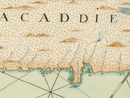
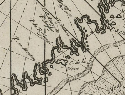
Mahone bay is located to the east of La Hève (usually on the right). There have been many names associated with the Mahone area: Mirligueche, Anse des Fournaises, Mirliouche, Isles Martyres
![[Carte de Terre-Neuve et Acadie] Faict à Plesance par Pierre Detcheverry .png](https://static.wixstatic.com/media/58bf1d_9fbf7b0b336b4e6086e6facefdf1635d~mv2.png/v1/fill/w_426,h_324,al_c,q_85,usm_0.66_1.00_0.01,enc_avif,quality_auto/%5BCarte%20de%20Terre-Neuve%20et%20Acadie%5D%20%20Faict%20%C3%A0%20Plesance%20par%20Pierre%20Detcheverry%20.png)
1
Title: Carte de Terre-Neuve et Acadie / Faict à Plesance par Pierre Detcheverry ; pour Monsieur Parat gouverneur de plesance en lisle de Terre Neuve,
Author: Pierre Detcheverry
Date: 1689
Source: Bibliothèque nationale de France
Link: https://gallica.bnf.fr/ark:/12148/btv1b5905624p/f1.item.r=acadie.zoom#

2
Title: Carte de la coste de l'Acadie / De Laborde La Borde, Jean-Benjamin de (1734-1794).
Author: Laborde
Date: 1700's
Source: Bibliothèque nationale de France
Link: https://gallica.bnf.fr/ark:/12148/btv1b53089980h/f1.item.r=carte%20nova%20scotia.zoom#

3
Title: A map of New Scotland
Author: ?
Date: 1700's
Source: Bibliothèque nationale de France
Link: https://gallica.bnf.fr/ark:/12148/btv1b53089477b/f1.item.r=carte%20nova%20scotia.zoom#

4
Title: Carte de l'Acadie Monsieur de Chavagne
Author: De Chavagne
Date: 1701
Source: Bibliothèque nationale de France
Link: https://gallica.bnf.fr/ark:/12148/btv1b53089760x/f1.item.r=carte%20nova%20scotia.zoom
_%20Cartographe%201746_pn.png)
5
Title: Carte de l'Accadie / De Chabert Chabert, Joseph-Bernard de (1724-1805). Cartographe
Author: Joseph-Bernard De Chabert
Date: 1746
Source: Bibliothèque nationale de France
Link: https://gallica.bnf.fr/ark:/12148/btv1b53089771s/f1.item.r=carte%20nova%20scotia.zoom#

6
Title: A new chart of the coast of New England Nova Scotia New France or Canada
Author: ?
Date: 1744
Source: Bibliothèque nationale de France
Link: https://gallica.bnf.fr/ark:/12148/btv1b53089469t/f1.item.r=carte%20nova%20scotia.zoom#
_%20Cartographe.png)
7
Title: Carte de l'Accadie / Bellin Bellin, Jacques-Nicolas (1703-1772). Cartographe
Author: Jacques-Nicolas Bellin
Date: 1744
Source: Bibliothèque nationale de France
Link: https://gallica.bnf.fr/ark:/12148/btv1b530895857/f1.item.r=carte%20nova%20scotia.zoom#

8
Title: A New Map of Nova Scotia, and Cape Britain. With the adjacent parts of New England and Canada , composed from a great number of actual surveys ; and other materials regulated by many new astronomical observations of the longitude aswell as latitude...
Author: Thomas Jeffereys
Date: 1755
Source: Bibliothèque nationale de France
Link: https://gallica.bnf.fr/ark:/12148/btv1b53177676x/f1.item.r=carte%20nova%20scotia.zoom

9
Title: Carte des costes de l'Acadie depuis le passage de Fronsac jusqu'à la rivière St Jean
Author: ?
Date: 1600's
Source: Bibliothèque nationale de France
Link: https://gallica.bnf.fr/ark:/12148/btv1b53089728v/f1.item.r=carte%20nova%20scotia.zoom

10
Title: A Plan from Halifax to Canso Lange, André
Author: André Lange
Date: 1700's
Source: Bibliothèque nationale de France
Link: https://gallica.bnf.fr/ark:/12148/btv1b530899794/f1.item.r=carte%20nova%20scotia.zoom

11
Title: Pas-Kaart, vande zee-kusten van Terra Nova met de Byleggende zee-kusten van Francia Nova Canada en Acadie van C. de Sables tot de Mond van de Straad Davids toe Door C.J. Vooght Geometra
Author: Joannes van Keulen
Date: 1687
Source: Médiathèque de Bayonne
Link: https://www2.bilketa.eus/ark:/27020/B641026201_GC187/v0001.simple.selectedTab=record
![Carte gé[né]ralle du voyage que Mons[ieu]r De Meulles intendant de la justice.png](https://static.wixstatic.com/media/58bf1d_24f7a9eb9d0d456b93ce676bdd039cb1~mv2.png/v1/fill/w_426,h_324,al_c,q_85,usm_0.66_1.00_0.01,enc_avif,quality_auto/Carte%20g%C3%A9%5Bn%C3%A9%5Dralle%20du%20voyage%20que%20Mons%5Bieu%5Dr%20De%20Meulles%20intendant%20de%20la%20justice.png)
12
Title: Carte généralle du voyage que Monsieur De Meulles intendant de la justice
Author: Franquelin, Jean-Baptiste
Date: 1686
Source: Bibliothèque nationale de France
Link: https://gallica.bnf.fr/ark:/12148/btv1b55012939c/f1.item.r=carte%20nova%20scotia.zoom#

13
Title: Carte des côtes de l'Acadie
Author: ?
Date: 1600's
Source: Bibliothèque nationale de France
Link: https://gallica.bnf.fr/ark:/12148/btv1b53089908s/f1.item.r=carte%20nova%20scotia.zoom

14
Title: Carte particulière des côtes de l'Acadie
Author: ?
Date: 1702
Source: Bibliothèque nationale de France
Link: https://gallica.bnf.fr/ark:/12148/btv1b53090015n/f1.item.r=carte%20nova%20scotia.zoom

15
Title: Carte réduite de l'Acadie ou Nouvelle Ecosse / Dépôt France. Dépôt des cartes et plans de la marine. Cartographe
Author: Dépôt des cartes et plans de la marine
Date: 1778
Source: Bibliothèque nationale de France
Link: https://gallica.bnf.fr/ark:/12148/btv1b53089768h/f1.item.r=carte%20nova%20scotia.zoom#
_%20Cartographe.png)
16
Title: Map of Nova Scotia or Acadia
Author: John Montresor
Date: 1768
Source: Bibliothèque nationale de France
Link: https://gallica.bnf.fr/ark:/12148/btv1b530899364/f1.item.r=carte%20nova%20scotia.zoom